The High Road
With perfect curves, corners, turns, spectacular valleys and the soft caress of misty clouds, the road from Lydenburg to Hazyview is a temptress. Best handled with reverence, care and respect, it also takes a bit of daring.

To many a traveller, commuter and motorcyclist, the Long Tom Pass is the entry to the Lowveld. This iconic road is steeped in rich history, and with superb engineering, it is the starting point of an incredibly interesting tour from Mashishing/Lydenburg to Sabie. The extension of this undulating tar serpent is the world-renowned “22”. This is the R536 between Sabie and Hazyview.

To understand riders’ and drivers’ fascination with the curves, twists and turns of this route, I go in search of those in the know. My first ride over Long Tom Pass on a bike had me shaking in my boots by the time I reached Sabie. Mostly because I did not have the experience or knowledge of taking a motorcycle through the route’s countless twists and turns.
Brian is well known as a leather’s man. He believes in its protection and durability to safeguard one during a fall on tar roads.
“I always wanted to ride a bike, but couldn’t afford it. In 1993 I decided to stop smoking and used the funds to pay for my first motorcycle,” says Brian. Since then he has owned several others including a Ducati, four Aprilias and several BMWs. Because of his racing background he likes riding the fast routes - like the infamous “22”. The R536 is a sports-car driver and speed biker’s dream experience: 76 varying curves in the first 22 kilometres from Sabie to Hazyview.
From easy, gentle curves to the treacherous “Kawasaki Corner”. “It has a few names but generally ‘Kawasaki Corner’ stuck. If you walk off the outside of the turn you will find numerous bike parts among the tall grass and bush,” says Thomas, adventure and road-riding instructor at Sabie Valley Rider Academy.

Photo: Benno Stander
Yes, you heard me correctly. This stretch of road is so popular that they named several of its winding turns. Thomas names them off by heart. “When riding from Sabie there is ‘Cold Tyre Corner’, then it is ‘The Bowl’. Because the view resembles a salad bowl. After that comes the ‘Bus Stop’. Which is logically so named because of the bus stop on the side of the road,” he says. Other names include “Baboon Ally”, a straight section where these animals are known to cross the road in hasty fashion, and also “The Chicane”.
Speaking of “The Chicane” reminds Brian of an incident where a young rider, dressed in shorts and hiking boots with only a lightweight bike jacket, lost control of his motorcycle. “He survived the fall, but had a very bare and painful butt for a long while. I always tell the guys to wear all their protective gear, all the time. I prefer to wear a full leather suit made for speed bikers.”
 Brian suggests that you as a biker must first do a slow ride of the route, to scope out hazards such as rubble, dirt or slippery diesel spills on the road surface. Once you have familiarised yourself with possible dangers, you can attempt the high-speed run.

You can’t only talk of the rigours of the “22” without also looking up and down the Long Tom Pass. I am fortunate to meet the surveyor of the road, Jim Morris. He is an avid biker and used to ride in rallies with Suzuki. Jim is one of the few people I know who has competed in the Roof of Africa in a modified Ford F250 in the 1970s. And yes, he has the photos to prove it. I discover that his knowledge of the road design and construction gives him an added advantage. Jim’s explanation of the process of surveying the road as it is today, fascinates me. The original pass survey included low-altitude aerial photographs and photogrammetry. It was used to draw and determine the contour lines along which the road was to be built.

“Because of this technology we were able to construct every perfect curve, turn and super-elevation of the road,” he says. The set radius turns and well-calculated camber angles make this one of the safest roads in the region. Due to external factors such as heavy trucks and constant traffic on this route, riding becomes a challenge and to some a test in patience.

From a biker’s point of view, it means if you get it right going into the curve, you just need to keep your speed, lean angle constant and relaxed to make it to the exit,” says Jim. The man certainly leads a charmed life. A small fact I have realised on several occasions following Jimbo down the Long Tom Pass, trying my best to keep up with him. The main difference between these two sections of road is there is only one set radius curve among the 76 of the “22” (R536).

Long Tom has spectacular views at designated viewpoints. Early mornings and afternoons can result in dense fog and wet-surface conditions that will have a chilling effect on you as you ride towards the highest point. Be prepared. Wear warm layers under your gear as being cold on a ride will make you tense up and may spoil your experience. As they say in the movies: go forth and conquer! If your fear gets the better of you when tempted by the seductive curves, turns and bends of the tar serpent; remember to smile into your helmet.

END
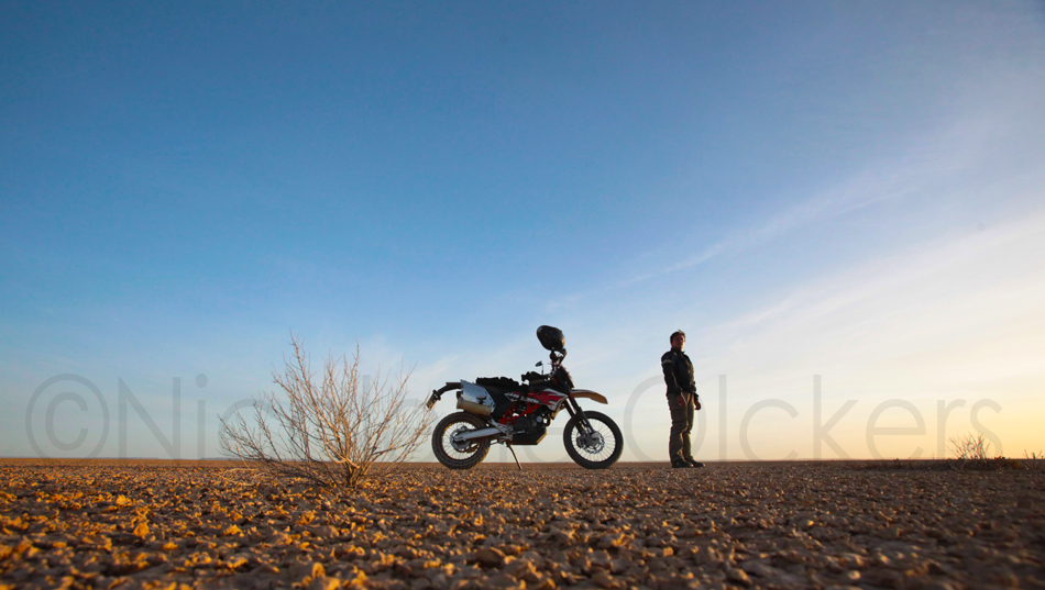
Flash in Verneuk Pan
As an explorer at heart and a biking adventurer for only a few years, I'm considered a newbie. The blue sky is limitless and the adventures only get better with experience.Getting rid of the old trusty steed - BMW F650 GS Dakar - can be a major step and a huge learning experience.


I bought a new steed - motorbike - and my day-dreaming sessions infront of Google-Eath on my computer, soon had me putting a sketchy plan on paper.
The plan was to ride from Johannesburg to Cape Town with only four days to do so sound silly and rushed. But once again as was customary with my December holiday plans, they aren't always well-planned. The idea was there but the logistics came when the ride was already underway. (I apologise to the serious and experienced dual purpose adventure bikers out there. I'm learning as I go.)
The only definite was having a sleepover on Verneuk pan and get the feel for the new bike. It was christened 'Kokka'. (Gogga, but because the kid couldn't pronounce the g it came out: Kokka)


I have long been wanting to visit Verneukpan. Situated in the Northern Cape Province it was the site chosen by Sir Malcolm Campbell for his land speed record attempt in 1929. The flat surface is estimated to be 57 kilometres long and 11 kilometres wide. Temperatures can rise to well over 40*C during the day. The pan is known to be deceiving with dust devils and mirages being a common occurrence during these hot days.

The track that Campbell had prepared is still visible today and has become a favorite destination for adventure bikers to try their mettle at high speed. The 26km long track run in a direct West-East direction. I stayed one night here and the wind never stopped blowing. The sun set was spectacular.
Camping facilities are available with an open air kitchen and a "put-the-money-in-the-tin" for payment of any drinks taken. Two caravans serving as 'luxury' accommodation can sleep four people in wind-free comfort. A donkey system provide hot water for showers.
Bookings and fees: www.verneukpan.co.za
End
Old Roads Revisited

The legends of Rain Queens and adventurous boers make for a mystical mix that has left behind a trail of wonderous places to visit. Nicolene Olckers attempts to follow the 1837 ox-wagon trail of Louis Trichardt en route to Maputo, Mozambique.
 I am inspired by the people who have explored this great country we call South Africa. From the first seafarer who rounded the Cape, Bartolomeu Dias to those trekboers with their canvas-covered ox wagons who left the Cape in hope of finding land for themselves. I stand amazed at the vast country they discovered. Places that are still shrouded in mystery, intrigue and ancient plants.
I decided to venture across the provincial border to our neighbouring province of Limpopo. My plan was to find the trail of pioneers and boer traders. It was while speaking to a friend and resident in the Tzaneen area that my interest was piqued in the rule of the Rain Queen at Bolobedu. From the book of E Jensen Krige titled The realm of a Rain Queen, it is clear that the westerners were as enthralled by the mysterious queen as her subjects.

 The last Rain Queen was inaugurated in 2003 at the of age 25. According to reports in local newspapers, Makobo Constance Modjadji became the sixth Rain Queen.
She was the youngest yet and the first to be educated and serve as Rain Queen. She died in 2005, and rumour had it that her niece, Masalanabo Modjadji was to be crowned at the age of 11.
At the Modjadji Cycad Reserve the small “museum” or information centre, seemed bare and looted, the basic history of her kingdom laid to waste, the information plates last updated in 1982. As we walk into the cycad forest, I can only imagine that many travellers and explorers must have gazed with wonder at the ancient trees. The forest, with these giants towering to impressive heights over the trail, dates as far back as the time of the dinosaurs.
From a distance they could be mistaken for palm trees but on closer inspection you see the magnificent cycads, several crowns of which tower at least 10m into the sky. Others with multiple squat stems branch off and curl to form a new head or crown. The newly hatched leaves are silky soft but once unfurled and extended the leaves are hard, spiky and waxy, providing a natural deterrent to intruders and unwanted guests alike.
The living cycad fossils have survived storms and political change. It is said the seeds from the female plant were ground to a fine flour and used for baking.
It was later discovered that this custom caused illness similar to Alzheimer’s and was stopped.
I stand there considering what Louis Trichardt must have thought as he probably passed through the valley. He left the Cape in 1836 and made his way north to explore. His party of 58 Voortrekkers included his wife and sons. The journey from the Soutpansberg area to modern-day Maputo would take seven months to complete.
The trekkers spent two and a half months finding a route down the Drakensberg escarpment by which time their stock was depleted by tsetse flies, and many of the men and women died of malaria. According to Trichardt’s diary, only 27 of his party arrived in Delagoa Bay in 1838.
 His route is not well documented and entries from his diary and the book on his wife’s writings shed very little light on the actual route along which they must have travelled to Delagoa Bay.
I am guided by a very vague basic map I found on the Internet and thus make my way in a south-south-easterly direction. From Balobedu Cycad Forest I cruise along a tar road through Modjadji and Magoebaskloof and head to a place named The Downs.
This route is clearly marked on a 1917 edition of roadmaps by the former Transvaal Automobile Association as a dotted line. According to the map legend, the route is listed as “doubtful”.
On today’s maps and GPSes the road is an unpaved invitation to adventure that leads from Trichardstdal to the Lekgalameetse Precinct Wildlife Resort.
At the entrance I am issued a permit and informed of the sites to be seen along the road. To my surprise the road in the reserve is tarred but it soon ends in a two-track trail that is slightly rutted. I am distracted by a dazzle of zebras and elands grazing on the grassland, and take a tumble as I look away from the road. Fortunate to have nothing broken and no injuries, I pick up the bike and continue.
The reserve which straddles the Strydpoort and Drakensberg, features rolling grass planes and sheer cliffs. Due to the little rainfall the roads are dry and very dusty.
The hard-baked red earth has been pounded to a fine powder in places by heavier 4x4 vehicles and some deceptively sandy curves make for tricky manoeuvring. I soon find the dirt changing to teeth-jarring rocky descents and narrow tracks, with stomach-churning chasms at the side of the road. By the time I arrive at the outgoing gate where two rangers look at me in amazement, I am hot and thirsty.

I must have been a sight. Dusty and sweating and with shaking knees I manage to get off my bike to take a break in the shade of a nearby tree. The ranger tells me that there is only a small section of bad road that I have to look out for, but for the next
10km I am shaken, rattled and jostled by the rocky road. Sharp turns and switchbacks on stones and washaways aren’t made any easier on the downhills and the steep ascents have me gripping the handlebars with force.


 The yawning drop on the side of the road offers wide views of a deep valley. The indigenous bush provides shade, but the dappled shadows make it difficult to spot the odd sharp stones. Again I am thankful for the wonderful invention of suspension and wonder what it must have been like to come down a mountainside in an ox wagon with little to a no-braking system and only a very basic suspension.
I am relieved when I arrive at the new bridge crossing over the Olifants River near GaMafefe Village. My route from here follows the banks of the river and passes through several rural villages towards Ga Malepe and ultimately to Penge.


 At Matlawane the river is a flat flood plain with islands dotted with resting cattle and the vibrant chatter of children enjoying an early spring swim. I do the same and have to cope with wet clothes on my way home.
But it is between Alverton and Maahlashi that I chance upon another mystical find. The Transvaal candelabra trees (Euphorbia cooperi) stand tall in the relentless heat. Their trunks are like plated armour against the elements, and they can grow to 10m high. I later discover that this plant is not as innocent as it looks. The white sticky sap is poisonous to man and animal. When it comes into contact with skin, it causes blisters and even the fumes from burning the plant can cause breathing complications.
In some of the nearby villages it is planted as a natural fence with the sharp spines causing burning irritations when touched.


A few careful photos later I am en route to Kaspersnek, with a quick snack stop at Johnny’s Pub in Pilgrim’s Rest and then home before dark.
END
Mac-Mac Kloofing thrills, Sabie
We descend 140 metres down into the Mac Mac Falls ravine to go kloofing with Sabie's adventurer extraordinaire, Kestell Barnard and his sure-footed dog, Wouter.

Standing in the parking area of the Mac Mac Falls viewpoint waiting for the other hikers to arrive, Kestell hands out helmets and wetsuits. "If you get cold easily it is best to don a wetsuit," he says. The helmet is to protect your head if you should fall. We shuffle around in anticipation. Some change into the provided wetsuits before Kestell gives us a short briefing on our designated route.

To get to the floor of the ravine we would have to climb, hop, jump and bum shuffle over boulders, fallen trees and wade through the cool water. It's not as extreme as it sounds but you should be sure-footed and be used to an active lifestyle. Hiking experience is preferable.


The route originally mapped and self-discovered by Kestell takes us down the side of the ravine under the cover of lush indigenous forest. The shade is most welcome as it is one of the hottest days, with temperatures soaring over 40ºC. He sets a comfortable pace with frequent rest stops making for an easy hike that lasts four to five hours.
At the start of the route we do some rock hopping and wade through ankle to calf-deep water. We slide down a slippery tree trunk fireman-style to get to our first rock pool for a cooling swim and daring jump from a three to four-metre-high rock into the pool. Kestell shows us how it is done and we soon follow him over the edge. Some with a thrilling shriek that resonates off the high ravine walls.


The Mac Mac Falls and ravine were named after the Scottish miners who were prospecting for gold around the area during the 1870 gold rush. The river drops over a sheer 70-metre cliff to the clear pool below at the head of the ravine.
Progressing along the route we bum shuffle and climb over boulders, rocks and fallen tree trunks, criss-crossing over the river as we go. Kestell leads us into beautiful scenery and an awe-inspiring crag with a noisy waterfall that few people have seen. To get there we have to swim as the water is too deep to wade through. The thin strip of blue sky overhead is the only proof that the day out there is sweltering
.


Kestell is the only guide with a permit to take hikers into the Mac Mac ravine and he has been doing so for six years. If he isn't kloofing the Mac Mac he takes adventurers geckoing, abseiling and caving in the Sabie and Graskop area.

We soon find ourselves staring up at the thundering rush of the falls. At the viewpoint 150 metres above tourists most likely look down on us with envy. Here we swim and get the opportunity to take a scream-inspiring leap into the water off the cliff side from about eight metres up. Currently the water levels are low but the pool is still deep enough to plunge into without touching the bottom.
Kloofing tips
•Wear shoes with good tread like tekkies or light hiking boots. Socks tend to trap the grit from wading through water, but the choice is yours.
• A helmet is provided. Keep the strap fastened at all times even when jumping into the water.
• It is preferable to dress in shorts and a T-shirt.
• After taking a jump into the first pool, your clothes remain wet and one can get cold. For this reason Kestell advises that hikers wear one of the wetsuits he provides. The wetsuit comes in handy for those of us that have short legs and have to swim occasionally as it provides floatation.
• Hikers can take a small backpack or camelpack if you want to take a camera and snacks. But Kestell provides a light snack and cold drinks at a rest spot. Keep it light and also waterproof whatever you put in your pack. You also need your hands to be free.
• Most importantly enjoy the views and have fun.
Get in touch
To book contact Kestell Adventures on 072-351-5553, at www.kesteladventures.com or info@kestelladventures.com
****END******
Explore Blue Sky country in Mpumalanga, South Africa
IT is time to take out your bike riding gear and head for hills, forests, dirt roads and those slightly far off places in the province.

Remember to check your bike’s oil and fluid levels before heading out on the road. IF your luck is anything like mine, make sure to pack the rain suit as well. Whether you plan to go on a tar or a gravel route be sure to have your brightly coloured reflective jacket on to ensure high visibility. If you are going on an off-road route be sure to have a puncture repair kit and or spare tube handy if your wheel s are the tube types.

Enjoy locally brewed craft beer. The Weis beer is particularly refreshing with a slice of lime and a scoop of ice.
Then get back the tingle of excitement in your toes as you swoop through the smooth curves of the Long Tom pass. If you are new to the area and the Long Tom Pass ask one of you fellow experienced rider to show you the lines to take through the curves. Don’t be shy to ask advice on riding some of the best twist and turns in Mpumalanga. Challenge yourself and make use of all the expensive rubber you have on your bike. If you are out early you might just be lucky enough to feel like you are riding on top of the world.

If your heart rate has not been raised by then, stop at Misty Mountain Lodge and take a wild ride on their downhill toboggan. Contact the lodge regarding fees and bookings.
Take into account that the logging season is in progress and most of the forestry roads are also used by logging trucks and machinery.
Making a full days ride and getting dirty is the goal. You have to spend at least a day or two cleaning the mean machine that carried you safely. Be sure to oil the chain if your bike is chain driven. Mud and water can take its toll on that shiny new chain and sprockets you had fitted and not used regularly.

 You can detour on the dirt road by taking the Louieville turn-.off that skirt alongside the Shiyalongubodam. This road links up with the Barberton Geotrail and amble through an indigenous forest with rich bird life and small game. This is also a great spot for an impromptu picnic. The Geotrail to Barberton have paved viewpoints where travelers can stop to read about the rich geological finds in the area. Get out there and explore the blue sky country.

Gideon Joubert Bridge over the Komati River was finish in 1958

Komati River valley

On the Shiyalongubodam Road

Forestry in the area

***END***
SoLo Trippin' Botswana and Namibia on my Dakar...
Part1_2...Botswana
The High Road
With perfect curves, corners, turns, spectacular valleys and the soft caress of misty clouds, the road from Lydenburg to Hazyview is a temptress. Best handled with reverence, care and respect, it also takes a bit of daring.
To many a traveller, commuter and motorcyclist, the Long Tom Pass is the entry to the Lowveld. This iconic road is steeped in rich history, and with superb engineering, it is the starting point of an incredibly interesting tour from Mashishing/Lydenburg to Sabie. The extension of this undulating tar serpent is the world-renowned “22”. This is the R536 between Sabie and Hazyview.
To understand riders’ and drivers’ fascination with the curves, twists and turns of this route, I go in search of those in the know. My first ride over Long Tom Pass on a bike had me shaking in my boots by the time I reached Sabie. Mostly because I did not have the experience or knowledge of taking a motorcycle through the route’s countless twists and turns.
Brian is well known as a leather’s man. He believes in its protection and durability to safeguard one during a fall on tar roads.
“I always wanted to ride a bike, but couldn’t afford it. In 1993 I decided to stop smoking and used the funds to pay for my first motorcycle,” says Brian. Since then he has owned several others including a Ducati, four Aprilias and several BMWs. Because of his racing background he likes riding the fast routes - like the infamous “22”. The R536 is a sports-car driver and speed biker’s dream experience: 76 varying curves in the first 22 kilometres from Sabie to Hazyview.
From easy, gentle curves to the treacherous “Kawasaki Corner”. “It has a few names but generally ‘Kawasaki Corner’ stuck. If you walk off the outside of the turn you will find numerous bike parts among the tall grass and bush,” says Thomas, adventure and road-riding instructor at Sabie Valley Rider Academy.
Photo: Benno Stander
Yes, you heard me correctly. This stretch of road is so popular that they named several of its winding turns. Thomas names them off by heart. “When riding from Sabie there is ‘Cold Tyre Corner’, then it is ‘The Bowl’. Because the view resembles a salad bowl. After that comes the ‘Bus Stop’. Which is logically so named because of the bus stop on the side of the road,” he says. Other names include “Baboon Ally”, a straight section where these animals are known to cross the road in hasty fashion, and also “The Chicane”.
Speaking of “The Chicane” reminds Brian of an incident where a young rider, dressed in shorts and hiking boots with only a lightweight bike jacket, lost control of his motorcycle. “He survived the fall, but had a very bare and painful butt for a long while. I always tell the guys to wear all their protective gear, all the time. I prefer to wear a full leather suit made for speed bikers.”
Brian suggests that you as a biker must first do a slow ride of the route, to scope out hazards such as rubble, dirt or slippery diesel spills on the road surface. Once you have familiarised yourself with possible dangers, you can attempt the high-speed run.
You can’t only talk of the rigours of the “22” without also looking up and down the Long Tom Pass. I am fortunate to meet the surveyor of the road, Jim Morris. He is an avid biker and used to ride in rallies with Suzuki. Jim is one of the few people I know who has competed in the Roof of Africa in a modified Ford F250 in the 1970s. And yes, he has the photos to prove it. I discover that his knowledge of the road design and construction gives him an added advantage. Jim’s explanation of the process of surveying the road as it is today, fascinates me. The original pass survey included low-altitude aerial photographs and photogrammetry. It was used to draw and determine the contour lines along which the road was to be built.
“Because of this technology we were able to construct every perfect curve, turn and super-elevation of the road,” he says. The set radius turns and well-calculated camber angles make this one of the safest roads in the region. Due to external factors such as heavy trucks and constant traffic on this route, riding becomes a challenge and to some a test in patience.
From a biker’s point of view, it means if you get it right going into the curve, you just need to keep your speed, lean angle constant and relaxed to make it to the exit,” says Jim. The man certainly leads a charmed life. A small fact I have realised on several occasions following Jimbo down the Long Tom Pass, trying my best to keep up with him. The main difference between these two sections of road is there is only one set radius curve among the 76 of the “22” (R536).
Long Tom has spectacular views at designated viewpoints. Early mornings and afternoons can result in dense fog and wet-surface conditions that will have a chilling effect on you as you ride towards the highest point. Be prepared. Wear warm layers under your gear as being cold on a ride will make you tense up and may spoil your experience. As they say in the movies: go forth and conquer! If your fear gets the better of you when tempted by the seductive curves, turns and bends of the tar serpent; remember to smile into your helmet.
END
Flash in Verneuk Pan
As an explorer at heart and a biking adventurer for only a few years, I'm considered a newbie. The blue sky is limitless and the adventures only get better with experience.Getting rid of the old trusty steed - BMW F650 GS Dakar - can be a major step and a huge learning experience.
I bought a new steed - motorbike - and my day-dreaming sessions infront of Google-Eath on my computer, soon had me putting a sketchy plan on paper.
The plan was to ride from Johannesburg to Cape Town with only four days to do so sound silly and rushed. But once again as was customary with my December holiday plans, they aren't always well-planned. The idea was there but the logistics came when the ride was already underway. (I apologise to the serious and experienced dual purpose adventure bikers out there. I'm learning as I go.)
The only definite was having a sleepover on Verneuk pan and get the feel for the new bike. It was christened 'Kokka'. (Gogga, but because the kid couldn't pronounce the g it came out: Kokka)
I have long been wanting to visit Verneukpan. Situated in the Northern Cape Province it was the site chosen by Sir Malcolm Campbell for his land speed record attempt in 1929. The flat surface is estimated to be 57 kilometres long and 11 kilometres wide. Temperatures can rise to well over 40*C during the day. The pan is known to be deceiving with dust devils and mirages being a common occurrence during these hot days.
The track that Campbell had prepared is still visible today and has become a favorite destination for adventure bikers to try their mettle at high speed. The 26km long track run in a direct West-East direction. I stayed one night here and the wind never stopped blowing. The sun set was spectacular.
Camping facilities are available with an open air kitchen and a "put-the-money-in-the-tin" for payment of any drinks taken. Two caravans serving as 'luxury' accommodation can sleep four people in wind-free comfort. A donkey system provide hot water for showers.
Bookings and fees: www.verneukpan.co.za
End
Old Roads Revisited
The legends of Rain Queens and adventurous boers make for a mystical mix that has left behind a trail of wonderous places to visit. Nicolene Olckers attempts to follow the 1837 ox-wagon trail of Louis Trichardt en route to Maputo, Mozambique.
I am inspired by the people who have explored this great country we call South Africa. From the first seafarer who rounded the Cape, Bartolomeu Dias to those trekboers with their canvas-covered ox wagons who left the Cape in hope of finding land for themselves. I stand amazed at the vast country they discovered. Places that are still shrouded in mystery, intrigue and ancient plants.
I decided to venture across the provincial border to our neighbouring province of Limpopo. My plan was to find the trail of pioneers and boer traders. It was while speaking to a friend and resident in the Tzaneen area that my interest was piqued in the rule of the Rain Queen at Bolobedu. From the book of E Jensen Krige titled The realm of a Rain Queen, it is clear that the westerners were as enthralled by the mysterious queen as her subjects.
The last Rain Queen was inaugurated in 2003 at the of age 25. According to reports in local newspapers, Makobo Constance Modjadji became the sixth Rain Queen.
She was the youngest yet and the first to be educated and serve as Rain Queen. She died in 2005, and rumour had it that her niece, Masalanabo Modjadji was to be crowned at the age of 11.
At the Modjadji Cycad Reserve the small “museum” or information centre, seemed bare and looted, the basic history of her kingdom laid to waste, the information plates last updated in 1982. As we walk into the cycad forest, I can only imagine that many travellers and explorers must have gazed with wonder at the ancient trees. The forest, with these giants towering to impressive heights over the trail, dates as far back as the time of the dinosaurs.
From a distance they could be mistaken for palm trees but on closer inspection you see the magnificent cycads, several crowns of which tower at least 10m into the sky. Others with multiple squat stems branch off and curl to form a new head or crown. The newly hatched leaves are silky soft but once unfurled and extended the leaves are hard, spiky and waxy, providing a natural deterrent to intruders and unwanted guests alike.
The living cycad fossils have survived storms and political change. It is said the seeds from the female plant were ground to a fine flour and used for baking.
It was later discovered that this custom caused illness similar to Alzheimer’s and was stopped.
I stand there considering what Louis Trichardt must have thought as he probably passed through the valley. He left the Cape in 1836 and made his way north to explore. His party of 58 Voortrekkers included his wife and sons. The journey from the Soutpansberg area to modern-day Maputo would take seven months to complete.
The trekkers spent two and a half months finding a route down the Drakensberg escarpment by which time their stock was depleted by tsetse flies, and many of the men and women died of malaria. According to Trichardt’s diary, only 27 of his party arrived in Delagoa Bay in 1838.
His route is not well documented and entries from his diary and the book on his wife’s writings shed very little light on the actual route along which they must have travelled to Delagoa Bay.
I am guided by a very vague basic map I found on the Internet and thus make my way in a south-south-easterly direction. From Balobedu Cycad Forest I cruise along a tar road through Modjadji and Magoebaskloof and head to a place named The Downs.
This route is clearly marked on a 1917 edition of roadmaps by the former Transvaal Automobile Association as a dotted line. According to the map legend, the route is listed as “doubtful”.
On today’s maps and GPSes the road is an unpaved invitation to adventure that leads from Trichardstdal to the Lekgalameetse Precinct Wildlife Resort.
At the entrance I am issued a permit and informed of the sites to be seen along the road. To my surprise the road in the reserve is tarred but it soon ends in a two-track trail that is slightly rutted. I am distracted by a dazzle of zebras and elands grazing on the grassland, and take a tumble as I look away from the road. Fortunate to have nothing broken and no injuries, I pick up the bike and continue.
The reserve which straddles the Strydpoort and Drakensberg, features rolling grass planes and sheer cliffs. Due to the little rainfall the roads are dry and very dusty.
The hard-baked red earth has been pounded to a fine powder in places by heavier 4x4 vehicles and some deceptively sandy curves make for tricky manoeuvring. I soon find the dirt changing to teeth-jarring rocky descents and narrow tracks, with stomach-churning chasms at the side of the road. By the time I arrive at the outgoing gate where two rangers look at me in amazement, I am hot and thirsty.
I must have been a sight. Dusty and sweating and with shaking knees I manage to get off my bike to take a break in the shade of a nearby tree. The ranger tells me that there is only a small section of bad road that I have to look out for, but for the next
10km I am shaken, rattled and jostled by the rocky road. Sharp turns and switchbacks on stones and washaways aren’t made any easier on the downhills and the steep ascents have me gripping the handlebars with force.
The yawning drop on the side of the road offers wide views of a deep valley. The indigenous bush provides shade, but the dappled shadows make it difficult to spot the odd sharp stones. Again I am thankful for the wonderful invention of suspension and wonder what it must have been like to come down a mountainside in an ox wagon with little to a no-braking system and only a very basic suspension.
I am relieved when I arrive at the new bridge crossing over the Olifants River near GaMafefe Village. My route from here follows the banks of the river and passes through several rural villages towards Ga Malepe and ultimately to Penge.
At Matlawane the river is a flat flood plain with islands dotted with resting cattle and the vibrant chatter of children enjoying an early spring swim. I do the same and have to cope with wet clothes on my way home.
But it is between Alverton and Maahlashi that I chance upon another mystical find. The Transvaal candelabra trees (Euphorbia cooperi) stand tall in the relentless heat. Their trunks are like plated armour against the elements, and they can grow to 10m high. I later discover that this plant is not as innocent as it looks. The white sticky sap is poisonous to man and animal. When it comes into contact with skin, it causes blisters and even the fumes from burning the plant can cause breathing complications.
In some of the nearby villages it is planted as a natural fence with the sharp spines causing burning irritations when touched.
A few careful photos later I am en route to Kaspersnek, with a quick snack stop at Johnny’s Pub in Pilgrim’s Rest and then home before dark.
END
Mac-Mac Kloofing thrills, Sabie
We descend 140 metres down into the Mac Mac Falls ravine to go kloofing with Sabie's adventurer extraordinaire, Kestell Barnard and his sure-footed dog, Wouter.
Standing in the parking area of the Mac Mac Falls viewpoint waiting for the other hikers to arrive, Kestell hands out helmets and wetsuits. "If you get cold easily it is best to don a wetsuit," he says. The helmet is to protect your head if you should fall. We shuffle around in anticipation. Some change into the provided wetsuits before Kestell gives us a short briefing on our designated route.
To get to the floor of the ravine we would have to climb, hop, jump and bum shuffle over boulders, fallen trees and wade through the cool water. It's not as extreme as it sounds but you should be sure-footed and be used to an active lifestyle. Hiking experience is preferable.
The route originally mapped and self-discovered by Kestell takes us down the side of the ravine under the cover of lush indigenous forest. The shade is most welcome as it is one of the hottest days, with temperatures soaring over 40ºC. He sets a comfortable pace with frequent rest stops making for an easy hike that lasts four to five hours.
At the start of the route we do some rock hopping and wade through ankle to calf-deep water. We slide down a slippery tree trunk fireman-style to get to our first rock pool for a cooling swim and daring jump from a three to four-metre-high rock into the pool. Kestell shows us how it is done and we soon follow him over the edge. Some with a thrilling shriek that resonates off the high ravine walls.
The Mac Mac Falls and ravine were named after the Scottish miners who were prospecting for gold around the area during the 1870 gold rush. The river drops over a sheer 70-metre cliff to the clear pool below at the head of the ravine.
Progressing along the route we bum shuffle and climb over boulders, rocks and fallen tree trunks, criss-crossing over the river as we go. Kestell leads us into beautiful scenery and an awe-inspiring crag with a noisy waterfall that few people have seen. To get there we have to swim as the water is too deep to wade through. The thin strip of blue sky overhead is the only proof that the day out there is sweltering
.
Kestell is the only guide with a permit to take hikers into the Mac Mac ravine and he has been doing so for six years. If he isn't kloofing the Mac Mac he takes adventurers geckoing, abseiling and caving in the Sabie and Graskop area.
We soon find ourselves staring up at the thundering rush of the falls. At the viewpoint 150 metres above tourists most likely look down on us with envy. Here we swim and get the opportunity to take a scream-inspiring leap into the water off the cliff side from about eight metres up. Currently the water levels are low but the pool is still deep enough to plunge into without touching the bottom.
Kloofing tips
•Wear shoes with good tread like tekkies or light hiking boots. Socks tend to trap the grit from wading through water, but the choice is yours.
• A helmet is provided. Keep the strap fastened at all times even when jumping into the water.
• It is preferable to dress in shorts and a T-shirt.
• After taking a jump into the first pool, your clothes remain wet and one can get cold. For this reason Kestell advises that hikers wear one of the wetsuits he provides. The wetsuit comes in handy for those of us that have short legs and have to swim occasionally as it provides floatation.
• Hikers can take a small backpack or camelpack if you want to take a camera and snacks. But Kestell provides a light snack and cold drinks at a rest spot. Keep it light and also waterproof whatever you put in your pack. You also need your hands to be free.
• Most importantly enjoy the views and have fun.
Get in touch
To book contact Kestell Adventures on 072-351-5553, at www.kesteladventures.com or info@kestelladventures.com
****END******
Explore Blue Sky country in Mpumalanga, South Africa
IT is time to take out your bike riding gear and head for hills, forests, dirt roads and those slightly far off places in the province.
With perfect curves, corners, turns, spectacular valleys and the soft caress of misty clouds, the road from Lydenburg to Hazyview is a temptress. Best handled with reverence, care and respect, it also takes a bit of daring.


To understand riders’ and drivers’ fascination with the curves, twists and turns of this route, I go in search of those in the know. My first ride over Long Tom Pass on a bike had me shaking in my boots by the time I reached Sabie. Mostly because I did not have the experience or knowledge of taking a motorcycle through the route’s countless twists and turns.
Brian is well known as a leather’s man. He believes in its protection and durability to safeguard one during a fall on tar roads.
“I always wanted to ride a bike, but couldn’t afford it. In 1993 I decided to stop smoking and used the funds to pay for my first motorcycle,” says Brian. Since then he has owned several others including a Ducati, four Aprilias and several BMWs. Because of his racing background he likes riding the fast routes - like the infamous “22”. The R536 is a sports-car driver and speed biker’s dream experience: 76 varying curves in the first 22 kilometres from Sabie to Hazyview.
From easy, gentle curves to the treacherous “Kawasaki Corner”. “It has a few names but generally ‘Kawasaki Corner’ stuck. If you walk off the outside of the turn you will find numerous bike parts among the tall grass and bush,” says Thomas, adventure and road-riding instructor at Sabie Valley Rider Academy.
 |
| Photo: Benno Stander |
Yes, you heard me correctly. This stretch of road is so popular that they named several of its winding turns. Thomas names them off by heart. “When riding from Sabie there is ‘Cold Tyre Corner’, then it is ‘The Bowl’. Because the view resembles a salad bowl. After that comes the ‘Bus Stop’. Which is logically so named because of the bus stop on the side of the road,” he says. Other names include “Baboon Ally”, a straight section where these animals are known to cross the road in hasty fashion, and also “The Chicane”.
Speaking of “The Chicane” reminds Brian of an incident where a young rider, dressed in shorts and hiking boots with only a lightweight bike jacket, lost control of his motorcycle. “He survived the fall, but had a very bare and painful butt for a long while. I always tell the guys to wear all their protective gear, all the time. I prefer to wear a full leather suit made for speed bikers.”


From a biker’s point of view, it means if you get it right going into the curve, you just need to keep your speed, lean angle constant and relaxed to make it to the exit,” says Jim. The man certainly leads a charmed life. A small fact I have realised on several occasions following Jimbo down the Long Tom Pass, trying my best to keep up with him. The main difference between these two sections of road is there is only one set radius curve among the 76 of the “22” (R536).


END
Flash in Verneuk Pan
As an explorer at heart and a biking adventurer for only a few years, I'm considered a newbie. The blue sky is limitless and the adventures only get better with experience.Getting rid of the old trusty steed - BMW F650 GS Dakar - can be a major step and a huge learning experience.

I bought a new steed - motorbike - and my day-dreaming sessions infront of Google-Eath on my computer, soon had me putting a sketchy plan on paper.
The plan was to ride from Johannesburg to Cape Town with only four days to do so sound silly and rushed. But once again as was customary with my December holiday plans, they aren't always well-planned. The idea was there but the logistics came when the ride was already underway. (I apologise to the serious and experienced dual purpose adventure bikers out there. I'm learning as I go.)
The only definite was having a sleepover on Verneuk pan and get the feel for the new bike. It was christened 'Kokka'. (Gogga, but because the kid couldn't pronounce the g it came out: Kokka)


I have long been wanting to visit Verneukpan. Situated in the Northern Cape Province it was the site chosen by Sir Malcolm Campbell for his land speed record attempt in 1929. The flat surface is estimated to be 57 kilometres long and 11 kilometres wide. Temperatures can rise to well over 40*C during the day. The pan is known to be deceiving with dust devils and mirages being a common occurrence during these hot days.

The track that Campbell had prepared is still visible today and has become a favorite destination for adventure bikers to try their mettle at high speed. The 26km long track run in a direct West-East direction. I stayed one night here and the wind never stopped blowing. The sun set was spectacular.
Camping facilities are available with an open air kitchen and a "put-the-money-in-the-tin" for payment of any drinks taken. Two caravans serving as 'luxury' accommodation can sleep four people in wind-free comfort. A donkey system provide hot water for showers.
Bookings and fees: www.verneukpan.co.za
End
Old Roads Revisited

The legends of Rain Queens and adventurous boers make for a mystical mix that has left behind a trail of wonderous places to visit. Nicolene Olckers attempts to follow the 1837 ox-wagon trail of Louis Trichardt en route to Maputo, Mozambique.

I decided to venture across the provincial border to our neighbouring province of Limpopo. My plan was to find the trail of pioneers and boer traders. It was while speaking to a friend and resident in the Tzaneen area that my interest was piqued in the rule of the Rain Queen at Bolobedu. From the book of E Jensen Krige titled The realm of a Rain Queen, it is clear that the westerners were as enthralled by the mysterious queen as her subjects.


She was the youngest yet and the first to be educated and serve as Rain Queen. She died in 2005, and rumour had it that her niece, Masalanabo Modjadji was to be crowned at the age of 11.
At the Modjadji Cycad Reserve the small “museum” or information centre, seemed bare and looted, the basic history of her kingdom laid to waste, the information plates last updated in 1982. As we walk into the cycad forest, I can only imagine that many travellers and explorers must have gazed with wonder at the ancient trees. The forest, with these giants towering to impressive heights over the trail, dates as far back as the time of the dinosaurs.
From a distance they could be mistaken for palm trees but on closer inspection you see the magnificent cycads, several crowns of which tower at least 10m into the sky. Others with multiple squat stems branch off and curl to form a new head or crown. The newly hatched leaves are silky soft but once unfurled and extended the leaves are hard, spiky and waxy, providing a natural deterrent to intruders and unwanted guests alike.
The living cycad fossils have survived storms and political change. It is said the seeds from the female plant were ground to a fine flour and used for baking.
It was later discovered that this custom caused illness similar to Alzheimer’s and was stopped.
I stand there considering what Louis Trichardt must have thought as he probably passed through the valley. He left the Cape in 1836 and made his way north to explore. His party of 58 Voortrekkers included his wife and sons. The journey from the Soutpansberg area to modern-day Maputo would take seven months to complete.
The trekkers spent two and a half months finding a route down the Drakensberg escarpment by which time their stock was depleted by tsetse flies, and many of the men and women died of malaria. According to Trichardt’s diary, only 27 of his party arrived in Delagoa Bay in 1838.

I am guided by a very vague basic map I found on the Internet and thus make my way in a south-south-easterly direction. From Balobedu Cycad Forest I cruise along a tar road through Modjadji and Magoebaskloof and head to a place named The Downs.
This route is clearly marked on a 1917 edition of roadmaps by the former Transvaal Automobile Association as a dotted line. According to the map legend, the route is listed as “doubtful”.
On today’s maps and GPSes the road is an unpaved invitation to adventure that leads from Trichardstdal to the Lekgalameetse Precinct Wildlife Resort.
At the entrance I am issued a permit and informed of the sites to be seen along the road. To my surprise the road in the reserve is tarred but it soon ends in a two-track trail that is slightly rutted. I am distracted by a dazzle of zebras and elands grazing on the grassland, and take a tumble as I look away from the road. Fortunate to have nothing broken and no injuries, I pick up the bike and continue.
The reserve which straddles the Strydpoort and Drakensberg, features rolling grass planes and sheer cliffs. Due to the little rainfall the roads are dry and very dusty.
The hard-baked red earth has been pounded to a fine powder in places by heavier 4x4 vehicles and some deceptively sandy curves make for tricky manoeuvring. I soon find the dirt changing to teeth-jarring rocky descents and narrow tracks, with stomach-churning chasms at the side of the road. By the time I arrive at the outgoing gate where two rangers look at me in amazement, I am hot and thirsty.

I must have been a sight. Dusty and sweating and with shaking knees I manage to get off my bike to take a break in the shade of a nearby tree. The ranger tells me that there is only a small section of bad road that I have to look out for, but for the next
10km I am shaken, rattled and jostled by the rocky road. Sharp turns and switchbacks on stones and washaways aren’t made any easier on the downhills and the steep ascents have me gripping the handlebars with force.


I am relieved when I arrive at the new bridge crossing over the Olifants River near GaMafefe Village. My route from here follows the banks of the river and passes through several rural villages towards Ga Malepe and ultimately to Penge.


But it is between Alverton and Maahlashi that I chance upon another mystical find. The Transvaal candelabra trees (Euphorbia cooperi) stand tall in the relentless heat. Their trunks are like plated armour against the elements, and they can grow to 10m high. I later discover that this plant is not as innocent as it looks. The white sticky sap is poisonous to man and animal. When it comes into contact with skin, it causes blisters and even the fumes from burning the plant can cause breathing complications.
In some of the nearby villages it is planted as a natural fence with the sharp spines causing burning irritations when touched.

A few careful photos later I am en route to Kaspersnek, with a quick snack stop at Johnny’s Pub in Pilgrim’s Rest and then home before dark.
END
Mac-Mac Kloofing thrills, Sabie
We descend 140 metres down into the Mac Mac Falls ravine to go kloofing with Sabie's adventurer extraordinaire, Kestell Barnard and his sure-footed dog, Wouter.

Standing in the parking area of the Mac Mac Falls viewpoint waiting for the other hikers to arrive, Kestell hands out helmets and wetsuits. "If you get cold easily it is best to don a wetsuit," he says. The helmet is to protect your head if you should fall. We shuffle around in anticipation. Some change into the provided wetsuits before Kestell gives us a short briefing on our designated route.

To get to the floor of the ravine we would have to climb, hop, jump and bum shuffle over boulders, fallen trees and wade through the cool water. It's not as extreme as it sounds but you should be sure-footed and be used to an active lifestyle. Hiking experience is preferable.


The route originally mapped and self-discovered by Kestell takes us down the side of the ravine under the cover of lush indigenous forest. The shade is most welcome as it is one of the hottest days, with temperatures soaring over 40ºC. He sets a comfortable pace with frequent rest stops making for an easy hike that lasts four to five hours.
At the start of the route we do some rock hopping and wade through ankle to calf-deep water. We slide down a slippery tree trunk fireman-style to get to our first rock pool for a cooling swim and daring jump from a three to four-metre-high rock into the pool. Kestell shows us how it is done and we soon follow him over the edge. Some with a thrilling shriek that resonates off the high ravine walls.


The Mac Mac Falls and ravine were named after the Scottish miners who were prospecting for gold around the area during the 1870 gold rush. The river drops over a sheer 70-metre cliff to the clear pool below at the head of the ravine.
Progressing along the route we bum shuffle and climb over boulders, rocks and fallen tree trunks, criss-crossing over the river as we go. Kestell leads us into beautiful scenery and an awe-inspiring crag with a noisy waterfall that few people have seen. To get there we have to swim as the water is too deep to wade through. The thin strip of blue sky overhead is the only proof that the day out there is sweltering


We soon find ourselves staring up at the thundering rush of the falls. At the viewpoint 150 metres above tourists most likely look down on us with envy. Here we swim and get the opportunity to take a scream-inspiring leap into the water off the cliff side from about eight metres up. Currently the water levels are low but the pool is still deep enough to plunge into without touching the bottom.
Kloofing tips
•Wear shoes with good tread like tekkies or light hiking boots. Socks tend to trap the grit from wading through water, but the choice is yours.
• A helmet is provided. Keep the strap fastened at all times even when jumping into the water.
• It is preferable to dress in shorts and a T-shirt.
• After taking a jump into the first pool, your clothes remain wet and one can get cold. For this reason Kestell advises that hikers wear one of the wetsuits he provides. The wetsuit comes in handy for those of us that have short legs and have to swim occasionally as it provides floatation.
• Hikers can take a small backpack or camelpack if you want to take a camera and snacks. But Kestell provides a light snack and cold drinks at a rest spot. Keep it light and also waterproof whatever you put in your pack. You also need your hands to be free.
• Most importantly enjoy the views and have fun.
Get in touch
To book contact Kestell Adventures on 072-351-5553, at www.kesteladventures.com or info@kestelladventures.com
****END******
Explore Blue Sky country in Mpumalanga, South Africa
IT is time to take out your bike riding gear and head for hills, forests, dirt roads and those slightly far off places in the province.
 |
Remember to check your bike’s oil and fluid levels before heading out on the road. IF your luck is anything like mine, make sure to pack the rain suit as well. Whether you plan to go on a tar or a gravel route be sure to have your brightly coloured reflective jacket on to ensure high visibility. If you are going on an off-road route be sure to have a puncture repair kit and or spare tube handy if your wheel s are the tube types.
If you are an experienced rider you know what to do. To refresh your memory and riding skills head out to Sabie either from MBOMBELA (Nelspruit) or via White River. If you get there early have breakfast at the Woodsman or why not make a change and try out fine fare at Sabie Brewery or The wild Fig Tree Restaurant.
 |
| Enjoy locally brewed craft beer. The Weis beer is particularly refreshing with a slice of lime and a scoop of ice. |
Then get back the tingle of excitement in your toes as you swoop through the smooth curves of the Long Tom pass. If you are new to the area and the Long Tom Pass ask one of you fellow experienced rider to show you the lines to take through the curves. Don’t be shy to ask advice on riding some of the best twist and turns in Mpumalanga. Challenge yourself and make use of all the expensive rubber you have on your bike. If you are out early you might just be lucky enough to feel like you are riding on top of the world.

If your heart rate has not been raised by then, stop at Misty Mountain Lodge and take a wild ride on their downhill toboggan. Contact the lodge regarding fees and bookings.
You can then brave the roads from Lydenburg to Dullstroom and enjoy lunch at one of the fine establishments there. The whiskey shop comes to mind.
For the more adventurous, the off road dirt roads around Kaapmuiden, Barberton, Kaapsehoop, Swaziland border, Badplaas and Chrissiesmeer offer a wide range to choose from.

Take into account that the logging season is in progress and most of the forestry roads are also used by logging trucks and machinery.
Another factor to consider is the recent rains. Roads used extensively by the loggers can proof challenging to beginners or novice dirt riders.
Making a full days ride and getting dirty is the goal. You have to spend at least a day or two cleaning the mean machine that carried you safely. Be sure to oil the chain if your bike is chain driven. Mud and water can take its toll on that shiny new chain and sprockets you had fitted and not used regularly.
Get an early start to make use of the best light for your pictures and utilise the cooler morning air. Pack snack in you top-box or camelback backpack to have a picnic along the route. Don’t forget the water.
Exploring a recent route, we ended the day at Badplaas. The route followed the service road between the rail-road track and the Kruger National Park fence from the Numbi gate to Masulu.
This sometime two-track dirt road can be challenging with washed-away low water bridges and slippery causeways. Do not ride this route alone.
From Matsulu you can make your way on tar to Louw’s Creek (R38) and on to Barberton.


You can detour on the dirt road by taking the Louieville turn-.off that skirt alongside the Shiyalongubodam. This road links up with the Barberton Geotrail and amble through an indigenous forest with rich bird life and small game. This is also a great spot for an impromptu picnic. The Geotrail to Barberton have paved viewpoints where travelers can stop to read about the rich geological finds in the area. Get out there and explore the blue sky country.
Things to see:
 |
| Gideon Joubert Bridge over the Komati River was finish in 1958 |
 |
| Komati River valley |
 |
| On the Shiyalongubodam Road |
 |
| Forestry in the area |

***END***
SoLo Trippin' Botswana and Namibia on my Dakar...
Part1_2...Botswana
I had a particular bad, busy time at work and booked annual leave to try and get some photographs done for my portfolio. The plan was to cover events and produce images that could be produced for interviews. I enjoyed the great biking weather and used the Dakar to go from one end of Jozi to the other. Four days into my leave i was sitting on the sidewalk watching Graffiti arstists and drinking beer bought at a shebeen when i realised i could do other things much more constructive. Like going on a bike trip! I did have a little over three weeks leave remaining. I went home and started packing. I stopped at a friend up from Cape Town in Harties and said i wanted to go on this trip but can't decide where to go. She had 2 maps, Namibia & Mozambique and there the plan to go through Botswana to Northern Namibia was set. I worked in Mozambique as a scuba instructor for a few years so that was done. Namibia it was.


Arriving at your destination - i love my samsung phone and the technology when i saw the man at the veterinary gate walking toward the gate i was ready to kis the ground. He gave me clear directions with distances to the signs.


 After pitching my camp i took my beer, camera and went around the Island on my bike taking pictures. I was the only camper there.!!


I crossed the Groblers Brug/Martin’s Drift border to Botswana early Friday morning and made my way to Palapye. Yes very boring and all on tar roads. Not for long as I left the bustling Palapye I found a dirt road that i seen on a map at the engen garage and decide to go that route to Serowe. Sand and more sand! After falling a few times it took me a while to get the hang of Jan Staal’s theory of sand riding. ( I done very little dirt or of road riding in the past year, a little here and there around JHB. If i remember correct i done the intermediate course at Country Trax in 2010?)The hardest work was picking up the Dakar and getting underway again. Thus I arrived in Serowe at Lenstwe Lodge in the late afternoon, sweating and dirty.

Crossing the Grobler’s Brug border

The topbox held my camerabag and other valuables. In the gearbag was my tent, spare choob and tools, Camping stove and emergency food supply, rain suit (The day i left JHB the rain started at Lanseria and I could only get out of my neon orange suit when I almost reached Thaazimbi), 2 sets of clothes and toiletries. (A woman thing I guess)
At the lodge in Serowe the owner looked a little confused when i told him i am alone and wanted to go to Khubu Island the next day and he advised against it. “The route is sandy track and becomes a two track and many get lost because of all the tracks,”he said. Despite his misgivings he directed me to Mmatsumo, where I had to make a booking to sleep over on LeKubu Island.
I arrived in Mmatsumo Sunday after noon and rushed to get underway. The “stoepsitters” told me it is about 50km to Kubu island. The previous sandy road experience left me nervous. By now I also knew that my GPS was doing funny things and i didn't have a printed Botswanamap. The only Botswana map i had was one that I photographed from a magazine at the Lodge in Serowe
I rushed thru some of the hard sections of the road i was directed but got sidetracked and ended taking a wrong turn. I took a right turn at a cattle gate which i thought was the gate that they explained to me and ended in sand that was way above my riding experience. I took one fall after the other and my confidence sank as deep into the sand as my boots.
By now i turned the GPS off because it kept on saying i should take a right turn, which i could not as there was a fence on either side and no road. With the last fall i became impatient and took off too fast, lost control and i ended in the mopani bushes. The Dakar suspended in the bush. I am lost and only had a small pocket knife to cut the bush to free the bike.
I decided to take a rest while the heat of the day past. I remembered i had a hot beer in my topbox and sat down to rest and rehydrate. I decided to try the GPS again and was informed that i now do not have a routable map installed. Next I decide to see if my mobile phone could help. BINGO!!! I felt like Mr Spock in Star Trek: Beam me up, Scotty???!!! But Jimbo (Jim Morris from http://www.thinkmike.co.za/) answered my call. While waiting for his sms of the correct coordinates i made some shade and had a snooze. I think he had good giggle when i said i was lost in the middle of the Makgadikgadi pans and do not know where i am. Jimbo beamed the coordinates of the Big boabab at Khubu to my phone and late afternoon i started to cut the bush to get the bike out. So now it was late and i was thru a lot of water and i had to decide what the plan was. Kobus Kotze (friend from scubadiving (www.twobar.co.za) said: Always go back to the place where you realised you are lost and then plan from there. I turned back to Mmatsumo and camped next to the community centre for the night.
Monday At the Gaing-O Community centre, Babsie tells me to stick to the middle road with the most tracks. “You will have no trouble getting there. It is easy!” Armed with my phone - gps essentials,google maps and Jimbos coordinates i set out toward Khubu Island.

Easy riding on hard surface with some sandy spots on the middle road. I was happier today. The weather was hot and the white dust was everywhere.
I was in awe when the track left the bush behind and made way for grass and a wide open view for my first ever view of the Makgadikgadi Pans. As Babsie said, it is dry and there is nothing once you arrive at this point. The ride across the pan to the veterinary gate is amazing and seem ..... unreal. Like going where no man has one before but there is a lot of proof that they have been there many times before.

The start of the ride across the MakgadiKgadi pans. This one before the Vet Gate and there are more on the way to KUBU
Arriving at your destination - i love my samsung phone and the technology when i saw the man at the veterinary gate walking toward the gate i was ready to kis the ground. He gave me clear directions with distances to the signs.

The Metal sign at the 7,5km right turn. Seventeen kilometres across another pan on which i was told i could go at 160 if i want. My arme Dakar!!!
Jim's coordinates was spot on and i arrived all alone at the Big KHubu Boabab. The voice on my phone said:....yes you guessed it: Arriving at your destination. This was no street view....


 After pitching my camp i took my beer, camera and went around the Island on my bike taking pictures. I was the only camper there.!!
The Boabab tree from the road marker.....


I made it. I arrived at midday and the heat was sweltering. Babsie made sure that I had more than enough water with me when I left Mmatsumo Village. I bought 2 beers and saved them as sun-downer drinks by which time they were warm, but still appreciated.
The blue rubber camping mattress was very uncomfortable by the time first light tinted the sky and I was up and ready to leave as the sun peeked over the far horizon of the pans.
The return trip was easier and felt much shorter. I arrived in Mmatsumo to find the local superette was already open at 8:00am. I summarily bought an ice cold beer and had some pictures taken with the locals.

With the rain-suit now packed at the bottom of the gear-bag I set off on the road to Namibia.
Part2_2....Namibia and the OwaHimba
....by the time I reach the Lake Ngami filling station at Nokaneng, I am truly tired of riding tar road. And it is also the first stop I am informed that they have no petrol/fuel......
Part2_3...Namibia .....
 |
| The result of a lost comb and helmet hair after nine days of biking. |

The heat and sandy track soon had me looking for an opportunity to head back towards the tar main road. The side-on wind made riding on the main road interesting specific when a big truck past in the opposite direction.
 |
| the tar-mac between Rakops and Maun |
Yes, it was boring on tar but I wanted to get to Maun and on to either Nokaneng or further towards Shakawe close to the Namibian border.
At Nokanneng is the dirtroad turnoff to Tsumkwe in Namibia. I heard about the beautifull Boababs close to the Botswana border and wanted to go have a look for awesome landscapes to photograph. In Maun I filled the bikes' tank with fuel and my water supply. While waiting for my change an interested tourist made small talk and was amazed that I was traveling on my own.
"Where are you heading?, he asked
"To Nokaneng and then Tsumkwe."
"We just came off that route. There is no fuel at Sehitwe and none at Nokaneng, there is some fuel at Gumare but I think they said they only had 95 LRP. "
So I was back to hording fuel in the Jimbo-system, 2 x 2L Coke bottles. I found they fit perfectly in my tent carry-bag and was then tied up with my luggage. The zipper allowed easy access when I needed to transfer the contents to the tank.
 |
 |
| At Nokaneng Shell |
By the time I reached the Lake Ngami filling station at Nokaneng, I was tired of riding tar road. And it is also the second stop I was told that they have no petrol/fuel but there was definitely fuel at Gumare. Aprox 49kms past the turnoff I wanted to take to Dobe/Tsumkwe.
I emptied the 2x2L into the tank and left for Gumare. Then end the days' riding in Shakawe. Turning back to Nokaneng would have me in the same dilemma with fuel. I found a place under a friendly lady's washing line and shared the backyard with a mother cat and her 4 kittens all black. Dinner was 2-minute noodles and chilli boelie beef, as it was to late to make my daily shopping stop at Choppies for dinner.
 |
| Under the washing line. The bin hanging in the tree was to prevent the kittens from getting in. |
 |
| Chilli Boelie Beef & 2 Minute noodles...emergency supplies!!! |
The owner of the backyard was very kind and gave me my first cup of filter coffee since I left home 6...umm 7? days ago.
Crossing into Namibia at Mohembo was quick and hasslefree. I was excited to ride the famous Namibia dirt roads and got an early taste after leaving the borderpost. The short 5-8 km dirt road met up with the tar main road running between Katimo Mulilo and Rundu. I realised I was following the banks of the Okavango river and the opportunity to ride across to the Katima check point was just an invitation to ride across the Okavango river Bridge twice.

 |
| Dirt road from the border to Rundu |
I found a very 'good' butcher along the way where i purchased a prime steak (hahahahaa!!!) and was on my way to find a camping-spot in Rundu.


I remembered a song by the afrikaans singer, Annelie van Rooyen and tried very hard to remember the tune.
Still is a nice song even if she is singing of the Chobe river and the Okavango delta. Link: http://youtu.be/em-URJoUEOk
Part 3_3...the Himba, Wambo, the best toes and a broken shock....

Part 3_3...the Himba, Wambo and the best toes
The day and a half in Rundu was beautiful. Having a swim in the mighty Okavango river, crocodiles or not was great. I wanted to go find the more traditional Himba to photograph and for that i needed to make my way across the north of Namibia towards Ruacana and then down to places like Okangwati and Opuwo. Yes you guessed it, dirt and more dirt roads. Prime Namibian dirt stuff.
Part 3_3...the Himba, Wambo and the best toes

Riding alone has its drawbacks. I would ride and not think much about taking pictures. But I have done some videoclips and will try to edit and upload these with links at the end. I found the gravel roads in Namibia well maintained and on occasion had to ride in the dust-trail of the graders. The surface would then have loose grit and was misleading to ride because of the colour and not being able to see any vehicle tracks.I managed to get the Dakar up to speeds in the 100s on the ungraded sections. Most of which had few or no corrugation. Riding at speed between 70-90km/h felt comfortable and the bike stable and surefooted or should I say sure-tyre. It did feel damn good to be off the tar-surfaces and away from most of the car-drivers. The route from Rundu to Oshakati was uneventful and I tried to ride longer sections of dirt.
 |
The blackline was the dirt road D3407 that i used to get to Nkurenkuru
|
I was surprised with road works detours and a no fuel stop at Nkurenkuru. Two boys came into town on their donkeys and after finding us waiting for fuel looked at me and said i should get one, they don’t use petrol.

 Asking around i was very happy to find Mémé, who had stashed 20L of unleaded petrol in her store and sold me enough to fill up my Jimbo-reserve as well before heading off to Okongo and Eenhana. This was boring and at times i would ride the track next to the road to get away from the gusty side-on wind.

I arrived in Oshakati in the dark and amidst a peak hour type traffic jam. Eventually camping at an expensive guest Lodge a R120 for the night. The worst was that the local HARD-ROCK-HIP-Hopping Disco was most likely three buildings down the road and sleep was impossible. By the time the music stopped dawn was showing and I tied my luggage to the Dakar to hit the road towards Tsandi and Onesi (D3616) and Opuwo via the D3617,D3640 and the D3720. D=Dirt.

I was told in Rundu that rain was few and far between and that these parts of Namibia have not had rain since October 2012. The drought was evident as i past cattle herders and their animals trekking to wells where there were pumps.
 Arriving in Opuwo on a Saturday before lunchtime was almost like arriving in Oshakatis’ traffics jam. The parkinglot at the OK Food store was packed with tourists and local hagglers. I was a little worried aout my luggage and sat on the kirbstone close to the Dakar, watching the goings-on. The traditionally dressed Himba and Hereros standing around was offended with me wanting to take pictures. They demanded i pay up as much as 20 Nam$ per person per picture!!!. I was in no mood to negotiate and my budget was pretty tight as most of my funds were spend on
1. petrol
2. water
3. accommodation
4. Food
I bought my food supply for supper and breakfast and found a comfortable campsite +-7km out of town at the community camp, Opuwo Mountain Camp. My shopping included 2 applesfor breakfast, Kudu wors, 1x tomato and onion, 3L water and two Windhoek Draught for at the fire and the evening.
Arriving in Opuwo on a Saturday before lunchtime was almost like arriving in Oshakatis’ traffics jam. The parkinglot at the OK Food store was packed with tourists and local hagglers. I was a little worried aout my luggage and sat on the kirbstone close to the Dakar, watching the goings-on. The traditionally dressed Himba and Hereros standing around was offended with me wanting to take pictures. They demanded i pay up as much as 20 Nam$ per person per picture!!!. I was in no mood to negotiate and my budget was pretty tight as most of my funds were spend on
1. petrol
2. water
3. accommodation
4. Food
I bought my food supply for supper and breakfast and found a comfortable campsite +-7km out of town at the community camp, Opuwo Mountain Camp. My shopping included 2 applesfor breakfast, Kudu wors, 1x tomato and onion, 3L water and two Windhoek Draught for at the fire and the evening.

Opuwo Mountain Community Camp
Once i settled in i took my camera and set off on foot to a village i spotted when I missed the turn for the camp. Monica said i could go and try to take pictures there. She advised me on a few protocols to follow. The people in the village were friendly and invited me into their homes and i sat with them at the fire trying to communicate. I young girl helped as much as her english allow and i gave the elders a packet of meelie meal and tea before starting to take pictures. The oldest woman posed for pictures with her grandchildren and the younger women came to show me their 1 week old babies.


They were getting by on the bare necessaties and i felt guilty for bringing only the one packet of meelie meal and tea. The kids were fascinated with my little camera and the screen at the back. They would push my head away so they could see the screen while i took the picture of their friends and family. I had to photograph all of them and show each of them their picture.
One kid, i can’t pronounce her name, had to touch my funny toes and compared her feet to mine and laughed as i wriggled my toes.
 The next day Monica escorted me to another village on the D3707. We met some French tourist that she met the previous day in town and would accompany us to Oukongo.

 I was thinking of the two small babies and the old woman who could hardly see as the flames danced on the wood of my evening fire. I have to go back there soon. The next morning i packed slowly to start the next leg of my trip.


I arrived in Oshakati in the dark and amidst a peak hour type traffic jam. Eventually camping at an expensive guest Lodge a R120 for the night. The worst was that the local HARD-ROCK-HIP-Hopping Disco was most likely three buildings down the road and sleep was impossible. By the time the music stopped dawn was showing and I tied my luggage to the Dakar to hit the road towards Tsandi and Onesi (D3616) and Opuwo via the D3617,D3640 and the D3720. D=Dirt.

I was told in Rundu that rain was few and far between and that these parts of Namibia have not had rain since October 2012. The drought was evident as i past cattle herders and their animals trekking to wells where there were pumps.

1. petrol
2. water
3. accommodation
4. Food
I bought my food supply for supper and breakfast and found a comfortable campsite +-7km out of town at the community camp, Opuwo Mountain Camp. My shopping included 2 applesfor breakfast, Kudu wors, 1x tomato and onion, 3L water and two Windhoek Draught for at the fire and the evening.
 |
| Opuwo Mountain Community Camp |
Once i settled in i took my camera and set off on foot to a village i spotted when I missed the turn for the camp. Monica said i could go and try to take pictures there. She advised me on a few protocols to follow. The people in the village were friendly and invited me into their homes and i sat with them at the fire trying to communicate. I young girl helped as much as her english allow and i gave the elders a packet of meelie meal and tea before starting to take pictures. The oldest woman posed for pictures with her grandchildren and the younger women came to show me their 1 week old babies.


They were getting by on the bare necessaties and i felt guilty for bringing only the one packet of meelie meal and tea. The kids were fascinated with my little camera and the screen at the back. They would push my head away so they could see the screen while i took the picture of their friends and family. I had to photograph all of them and show each of them their picture.
One kid, i can’t pronounce her name, had to touch my funny toes and compared her feet to mine and laughed as i wriggled my toes.
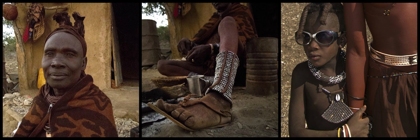

Part....Final...spoor, dirt tracks, passes and a shocking suspension.....

The plan was to go see the desert elephants at Puros and the seals at Cape Cross. I had alot of gravel to cover. The first dirt to Sesfontein –a 150km in clude the Joubert Pass. Long stretches of corrugations, low water “driffies” and a couple of kamikaze bakkie drivers out of the dust, forced me to slow down. With not much to see the kilometres rolled by quickly, next the Joubert pass was ahead. The road before the pass has many low water fords (afr: drif) and some had steep declines and inclines. For the first few i would slow down but got complacent and with the few of the deeper ones before the pass i heard this fun creaking sound from the bike. At first i didn't think much of it. At some point there was a clear "clack"sound but, i was on the uphill and could not loose momentum.

The road construction team waved me thru. As i went up the last steep rcoky section of the pass there was another clack and the Dakar was doing funny things. I found it hard to ride over the rocky parts of the pass. The steep downhill was harder to keep the bike on the tracks, At first I thought i had left the ABS on and it felt like the Dakar was shook at each stoney/rocky section we went over.
I felt well shaken by the time i reached easier ground. I stopped and as i put my feet down i knew something was wrong. I’m not very tall and is used to only getting my toes on the ground when riding my bike but suddenly i could set my feet flat on the ground. As i stood next to the Dakar it seemed to squat down on the back wheel but i could still ride.


I walked around taking a couple of pictures at the t-junction almost hoping it was not what i thought . Alas, pon further inspection this is what I found:

The shock absorbers’ bottom mounting was broken, the bolt and bush was missing and my guts was buried very deep in my off road boots. Basically the rear suspension now functioned on the spring only. The guys called this : riding a pogostick. I had a few spare parts in my bag, but another shock assembly wasn’t one of them. I made a careful ride to Sesfontein and was on the ground to see if i could push a spare bolt in to support the shock-mount but i quickly realised that i needed man-power to do the job. This guy stopped next to me and ask what i was doing in the dirt. “Nee meisie, ons laai hom op die bakkie en vat hom daar na die workshop toe. Die manne sal daar ‘n plan sien. Ons kan maar ‘n koue bier gaan drink terwyl hulle besig is.” I said that i could still ride the bike and he showed me the way to Fort Sesfontein Lodge. There Hugo and Rosvita quickly arranged with Petrus, the lodge mechanic to see what can be done.


The temporary solution.....the black square washer act as retainer and keep the broken end in place. And the Dakar was standing up cheecky again. Hugo said that it would be best to head for the tar roads to continue on my route. But my planned trip to Puros and Cape Cross was now a future excursion for another time. I will admit that i was a little disappointed....No i was in a foul mood. I had a beer in the shadowy gardens of the fort and on Petrus’s advise did a test run out on the main road. The Dakar seemed fine but my plans to look for elephants and seals were now definitely for another time. Hugo and his wife, Rosvita suggested i sleep at Palm wag as it was early in the day and the road was in good condition. Then try to reach the tar road at Khamanjab the next day. I thanked them for their help and they didn’t want payment as Hugo said it was a minor thing.
I decanted the 4L of petrol into the tank to have less luggage said my thank- yous and left for Palmwag, 113km away. I went through the only water crossing of my entire trip on this part of my journey . The road was beautiful, straight and lay endless ahead.
I decanted the 4L of petrol into the tank to have less luggage said my thank- yous and left for Palmwag, 113km away. I went through the only water crossing of my entire trip on this part of my journey . The road was beautiful, straight and lay endless ahead.


Palmwag campsite is an oasis with everything the road tired traveller need. A pool, restaurant, bar, tall palms and clean facilities. I particularly enjoyed the HOT shower that afternoon and used the hot weather to wash my socks, riding pants and other washing. I m a light traveller and the other set of clothes was by now getting smelly too.
I felt like having more than my quota of two beers to drown my sorrows and worries. The road to Khamanjab included riding over the Grootberg Pass and i felt a little (ANGSTIG)!!! I did check the shock-fix and made sure the bolts and nuts were tightened. I was having my customary 2nd beer when the owner of Palmwag, Fritz said he had spoken to Hugo. He offered to see if the fix was good and holding but i assured him that it had held in place. He set my mind at ease when he said that the Grootberg Pass was an easy smooth ride and i should be fine.
After crossing over the Pass i felt more at ease and opened the throttle a little more. The Dakar felt more secure on the road at about70-80km/h. I almost did ride over the chameleon and did a smooth swerve and emergency stop to photograph this dude that was pretty quick on his feet.
I felt like having more than my quota of two beers to drown my sorrows and worries. The road to Khamanjab included riding over the Grootberg Pass and i felt a little (ANGSTIG)!!! I did check the shock-fix and made sure the bolts and nuts were tightened. I was having my customary 2nd beer when the owner of Palmwag, Fritz said he had spoken to Hugo. He offered to see if the fix was good and holding but i assured him that it had held in place. He set my mind at ease when he said that the Grootberg Pass was an easy smooth ride and i should be fine.
 |
| Palmwag Campsite |
 |
| Springbok in the Grootberg Pass |
 |
| Going down the road in the distance |

He didn’t hesitate and made for higher ground when i lay in the road to get a good portrait of him/her.


From Khamanjab to Windhoek was without incidents. After my visit to BMW in Windhoek I made the cutomary stop at the famous and picturesk Church. I was in no mood to hang around and knew the long boring Trans Kalahari Highway lay ahead.
 |
| In Windhoek. |
I stopped at regular intervals at the picnic spots in Namibia. They were clean and well maintained and it was a pleasure to stop and have a cup of coffee and a rest at these well marked spots.


.... And here on the Rundu Oshakati road. The bins were empty and there were no litter lying anywhere nearby.
In contrast the roadside picnic spots in Botswana were in bad shape. Litter, bottles and sometimes dead animals made it disgusting.
My route home was on the trans Kalahari highway, Gobabis,Ghanzi, Kang, Jwaneng, Lobatse Zeerust and then Johannesburg. Very boring, nothing to see and lots of trucks day and night!
| The Trans Kalahari Highway |
I arrived in Jozi with the temporary shock-fix in place and no other damages. And a definite plan to go back to Namibia as soon as possible.
Being back I learnt a few lessons doing this trip. Plan plan plan....remember the printed maps....Unplanned detours to hip places is really great but you need to have a plan and a back-up. Don't rush, it can get complicated. I spent many times staring at the Southern-African map hanging in the corridor at work and i think i more or less knew what my planned route was long before doing this trip on the spur of the moment.
Things i think i did well was coping with falling in the sand, picking up the bike and continuing. Doing short sections of dirt, even if they where a little hard, help to build confidence when you do longer sections later in the trip. I say it is riding experience. the bike had a standard 70 000 km service at Lyndhurst BMW in February and i did not do proper nuts and bolts check before leaving.
I always had a lot of water, at one time 5L. 2L in my camelback and three in my luggage. And on occasion two (...or three) beers in the topbox. Don't carry it drink it.
I originally had 2 objectives,
1 to go photograph the Himba in Northern Namibia, and
2 to photograph the desert elephants and the Cape Cross seal colony.
My research was lacking-the spur of the moment.... For Botswana, always follow Babsie's advise take the road with the most tracks. In Namibia, SLOW DOWN, it is an impressive country.
Hey Nicky, awsome stuff!! Hats off to you.
ReplyDeleteRGS Mike.... (thinkmike)